Walking In Footsteps To The Future
July 26, 2019
When we try to recall what the great industrialists of the 19th century did and how they operated, we rely mainly on historical records, some of which are vague, or partial, or indecipherable. Certainly there is no living memory to help us, and there is very little physical evidence too.
In the case of John Marshall’s first two operations on Water Lane in Holbeck, the two flax spinning mills which kick-started the industrial revolution in Leeds in the 1790s, we have rough outline layout drawings and written descriptions of the work that went on there. Physical evidence of walls, chimneys, drains and cobbled courtyards have been unearthed below ground during recent excavations of the soon-to-be-developed land, but above ground there is just one piece of evidence that still stands today; the bridge that is considered to be of national importance because of its special historic or architectural interest.
A bridge can take you from one point to another, but it can be far more significant than that, particularly in a developing industrial landscape where transport is primitive and what we would consider to be minor obstacles are actually quite major, and need to be overcome. A bridge in this sense becomes the lifeblood of a working mill and far more than just an everyday conduit between two pieces of land separated by a body of water. To John Marshall, the bridge that traversed the Hol Beck and linked Water Lane to his developing Mills A and B, was his golden ticket to vast riches.
With Leeds at this time just a collection of disparate parishes surrounding the central hubbub of a burgeoning cloth trade on Briggate, something as simple as building a bridge to enable easier transportation of goods was blue-sky-thinking on a transformational scale. In the 1300s Leeds Bridge and a river crossing at Kirkstall, some three miles upstream, were the only pathways into or out of Leeds, and by the time John Marshall was developing a line of thinking that extended to national and international territories, there weren’t that many others.
This is why bridges were so important, not just as a functional structure, but as the key to unlocking a world of possibilities.
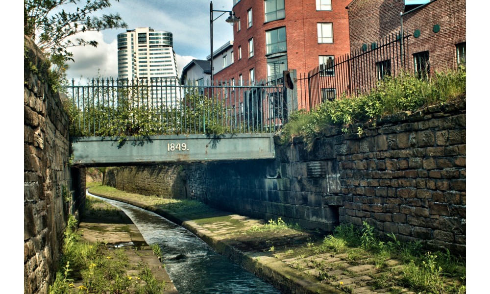
On Water Lane, the existing Grade ll-listed bridge is date-stamped with 1849, and alas, is not the original bridge. That is thought to have been a wooden construction that was built circa 1808, and before that a series of temporary constructions will have been used to transport Marshall’s early output from the mills.
The current bridge has a span of 5.5 metres, is 4 metres wide and is approximately 60 tonnes in weight. It consists of cast iron gate posts which are most likely original, cast iron beams and cast iron railings, with a concrete slab deckway that is separated into two zones, for pedestrians and goods traffic. An additional stone slab adjacent to the bridge measures two metres square, and is believed to be the location of a gatehouse hut previously, but the already damaged slab cracked during recent flood alleviation work and has had to be replaced.

(The listed bridge on Water Lane prior to the demolishing of the warehouse buildings. Photo Source: Northern Archaeological Associates)
Currently the bridge has been gated off for its own protection (and that of the public) and lies awaiting remedial work to restore it to its former glories. The bridge was inspected in July 2016 and the conclusion was that it was in fair condition, but remedial work was required in order to retain the bridge in its current state and to return it to pedestrian use. This structural survey took place because the Leeds Flood Alleviation Scheme had proposed to uplift the bridge and move it lock, stock and barrel 15 metres downstream to allow high volumes of water to flow more freely under it. Following negotiations, Southbank developer CEG paid a sum of £300,000 to provide upstream flood works in order to secure the bridge and retain it in its current and historical location. This sum will also allow other bridges to be built ‘on the flat’ over the Hol Beck, rather than bridges that have to rise far above the level of Water Lane.
The 1849 bridge was designated as Grade ll-listed in September 1996. It was originally designed to carry horse drawn traffic on a single lane roadway, but its wooden predecessor provided vital access between the late 18th century flax mills and the later 19th century mills and warehousing that Marshall developed on the south side of Water Lane on Marshall Street.
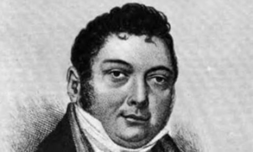
When Marshall initially bought the land on which he built his first two mills in 1790, this was undeveloped agricultural land. Marshall chose the location strategically and with prophetic forethought. It was the converging point of the Hol Beck, the Aire & Calder Navigation and the Leeds Liverpool Canal; allowing transportation both east and west out of Leeds. Water Lane was also part of the trans-Pennine route linking Leeds, Halifax and Manchester for overland transport. Marshall also sought to take advantage of the willing and available labour resources in Leeds and the adjacent hamlet of Holbeck.
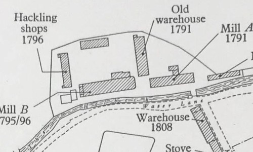
Before Marshall developed the land, the only access to it was across the beck. On the north side of the site, Globe Road had yet to be established, and wouldn’t be for another 60 years. Therefore, the construction of a bridge was a fundamental necessity, although the earliest depiction of a permanent structure on an ordnance survey map is 1815, with Marshall already shifting tonnes and tonnes of flax from both mills A and B by 1796. It is likely, therefore, that a temporary structure was in place to take Marshall’s early output off the site and away to the various accepting markets he had built up.
International trade in raw materials was heavily affected by the Napoleonic Wars (1803-15) which subsequently hit the flax industry hard. However, perhaps the single most significant move Marshall made in those early years, was in showing the prudence and premonition to stockpile raw materials in his warehouses on the occasions when flax prices dropped. He did this throughout the war period and in 1808 he built a new warehouse specifically for this purpose, which was located on the recently purchased land to the south of Water Lane. It is thought that at this time, Marshall built a permanent wooden bridge which was positioned exactly where the current listed bridge is.
This 1808 warehouse is today known as Marshall Court, and is itself a Grade ll-listed building. It could hold approximately 500 tonnes of flax and was constructed as one of the first all-steel fire-proof buildings in the world, following the disastrous fire that destroyed Mill B in 1795. Its cobbled areas to the rear show signs of industrial activity and this gated access is directly aligned with the bridge, so the suggestion is that the bridge was specifically built as a direct link to this rear warehouse access, not to the front of the warehouse on Marshall Street. The bridge, and this short crossing over Water Lane, therefore became essential in Marshall hoarding raw material and finished product and delivering on his plan to clean up while the rest of the industry dithered.
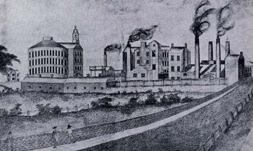
Both Mill A and B underwent substantial development between 1810 and 1814, while each were running at full capacity. By 1815, Marshall had expanded production south of Water Lane with the opening of Mill C. The industry was changing however, and in a bid to keep ahead of the competition, Marshall knew he had to adopt new techniques to increase product quality and manufacturing efficiencies. One of these was wet spinning, and both Mill A and B were adapted to accommodate the new processes, but they were eventually found to be unsuitable. Mill D was built specifically for wet spinning in 1825 and Mills A and B gradually ramped down their production and significance.
Mill A was demolished in 1837 with Mill B only in ‘light use’ as a training and small production facility until 1852 when it met a similar fate. By 1847, the position of the wooden bridge had changed slightly on maps, possibly to reflect this change in use of the land. There was still evidence of a weighing machine on the site of Mills A and B and hence, the bridge was still being used for the delivery and dispatch of goods, but two years later the current ‘1849’ bridge was constructed and located back at its original and existing location.
Given that, by 1849, Marshall’s occupation of the site north of Water Lane was largely at an end, it is likely that the construction of a permanent bridge was due to the industrial development of the wider Holbeck area that Marshall himself had instigated. This development had two-fold impacts.
On the positive side, Globe Road was established in 1850 and the Globe Iron Foundry (also now a listed building) – amongst many other new industrial sites - had also been developed north of Marshall’s site on land south of the River Aire. The bridge was mainly used as access to that. On the negative side, the wholesale industrialisation of the Holbeck area had resulted in work for many, but also brought overcrowding and poor living conditions. It is possible, therefore, that the construction of the bridge was undertaken in association with a programme of improvement works to the beck. Sanitary conditions in Leeds were undeveloped for the labouring classes and in a report submitted to the Leeds Board of Health in 1833, Water Lane was identified as one of many 'less cleansed areas', at risk from the spread of contagious disease. Watercourse improvement works were therefore part of a programme of wider sanitary improvements that were undertaken in response to cholera outbreaks in 1832 and indeed, 1849.
Although the Marshall Empire ended in 1886, at that time, the listed bridge was still the only crossing on to the family’s former land. By 1901 the Monk Bridge Bobbin & Shuttle plant used the bridge as a vital crossing and by 1908 a chemical works was resident on the land and had constructed a second bridge to the west of the original one. By 1953 there were as many as five bridges onto the land, but the original bridge was still being used. This ended in the late 1960s and early 1970s when the warehouses demolished in March and April 2019 were constructed, which blocked the bridge and immediately discontinued any practical use it had.
The £300,000 paid by CEG, and the cooperation of the Flood Alleviation Scheme team, has secured the conservation of a historic asset. The plan is to return the bridge to its designed use, at least in terms of pedestrian access, but most significantly, this has been done with the bridge’s historical location retained, after the Leeds Flood Alleviation Scheme originally believed that it had to be moved.
Opening the bridge back up in its original location is seen as being critical to retaining the historical context of the area. While the bridge lies within the Holbeck Conservation Area and is therefore one of several similarly listed buildings nearby, the location and purpose of the bridge has contributed to the historic perspective of the surrounding area and the many buildings within it.
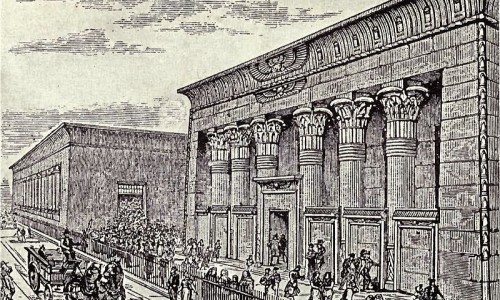
The significance of the bridge as a heritage asset can be considered by assessing its evidential, historic and aesthetic values. Evidentially, the bridge is significant in that it is the only surviving, over-ground evidence of Marshall’s first mills, it demonstrates evidence of the process flow in the mills and there is evidence of historic use of the bridge. Historically, the bridge holds a close association to John Marshall, an important industrial figure to the Holbeck area and to Leeds, plus the bridge reflects the influential role of the Hol Beck as a power source. Aesthetically, the bridge is an example of Victorian design and has many decorative features that have largely survived with little alteration. Properly restored it would also enhance the aesthetic value of the surrounding buildings, not just the nearby Marshall Mills complex, but also the 1808 warehouse (Marshall Court) and the 1898 printworks adjacent to it.

(The original cast iron railings of the listed bridge and the damaged gatehouse slab to the rear prior to it being replaced. Photo Source: Northern Archaeological Associates)
With CEG moving to secure the bridge and retain it in situ, attention has turned to what remedial work is required to restore the bridge to public use. Currently the bridge is overgrown with shrubbery and the gate posts and railings are in need of re-painting, but more significantly, some ironwork has corroded, footway slabs require strengthening, the concrete surface requires removing and waterproofing installing, and the abutments to the banking require re-pointing. In some cases the iron railings are no longer strong enough to meet modern safety standards, but like-for-like replacement should enable a sympathetic restoration and preserve the significance of the bridge.
Now, award-winning architects Feilden Clegg Bradley Studios are working on the final designs for the buildings on the Globe Point and Globe Square site, which will proudly showcase the restored bridge and re-appoint it as an important pathway in everyday use. An interpretation board will also be erected alongside the bridge, telling the Marshall story and how significant the bridge is to all the people passing by.
The eventual aim is for improved connections to be established from traditional Holbeck, through the re-developed former industrial area and into the heart of the city; opening up important links to re-connect a fractured area of Leeds.
Physically, and as part of the setting of regeneration centred on Temple Works, links will be vital that will take you past Temple Works along Marshall Street, over the listed bridge, across the CEG ‘Globe Point’ Water Lane site, across Globe Road, through new development sites and directly onto the southern bank of the Leeds waterfront, amongst other listed buildings that also used to rely on the bridge. In addition, landscaping and public realm will re-instate the bridge’s visibility and sense of purpose, providing a positive impact that may also influence street furniture in surrounding areas and integrate the historic bridge into the rejuvenated area.
In planning terms the benefits of providing attractive and accessible links into the city centre for all to use are obvious, and historically there is great value in recognising the important role the Hol Beck played in Marshall’s rapidly-expanding empire, as well as paying homage to the daily transportation of people and goods.
The restoration of the listed bridge will allow us to walk in the footsteps of those who built our city, it is a key element in linking the regeneration of Temple Works and the Holbeck area to the city centre and perhaps most importantly, it is a ‘bridge’ between the industrial heritage of Leeds and the exciting future it hopes to create.
(Lead image of the listed bridge from the Hol Beck is "Holbeck Tunnel" by jcw1967/Flickr and used with permission)
About Me

I am a Leeds-based freelance writer and author.
.jpg&w=500&h=300)